Thursday, September 2, 2010

Carson Saddle


Day 28

Miles hiked today: 22.9
Miles from Denver: 381.1
Elevation: 12,250 ft
Segments 22, 23
Landmarks: Continental Divide, Continental Divide Trail, Jarosa Mesa, Antenna Summit, Coney Summit, Carson Saddle, Cataract Lake

VIEW MAP

I was anxious to get moving quickly this morning, both because it was very cold and because I planned to do a lot of miles. There was frost on the ground, and I think I can expect the temperature to start to drop over the next week or so that it takes me to finish this trail.

I am trying to make it to Silverton by Saturday morning, because the post office has some stuff that I sent there, the most important of which being my camera battery charger. I thought I would be clever and save some weight by mailing it ahead, and now it will drive me to do extra miles each day and race the post office hours. This upcoming weekend is Labor Day weekend, so if I miss the P.O. on Saturday, I would have to wait until Tuesday or do without. The one thing I absolutely don't want to happen on this trip is to run out of battery in my camera.


So I started out at 7:30, counting on a listed "good water source" 2.5 miles in for my breakfast. That water source never materialized, and neither did my breakfast. I did see a bobcat however, and watched him stalk me through the grass for about 10 minutes. He never did get very close, and at one point I moved and he spooked.

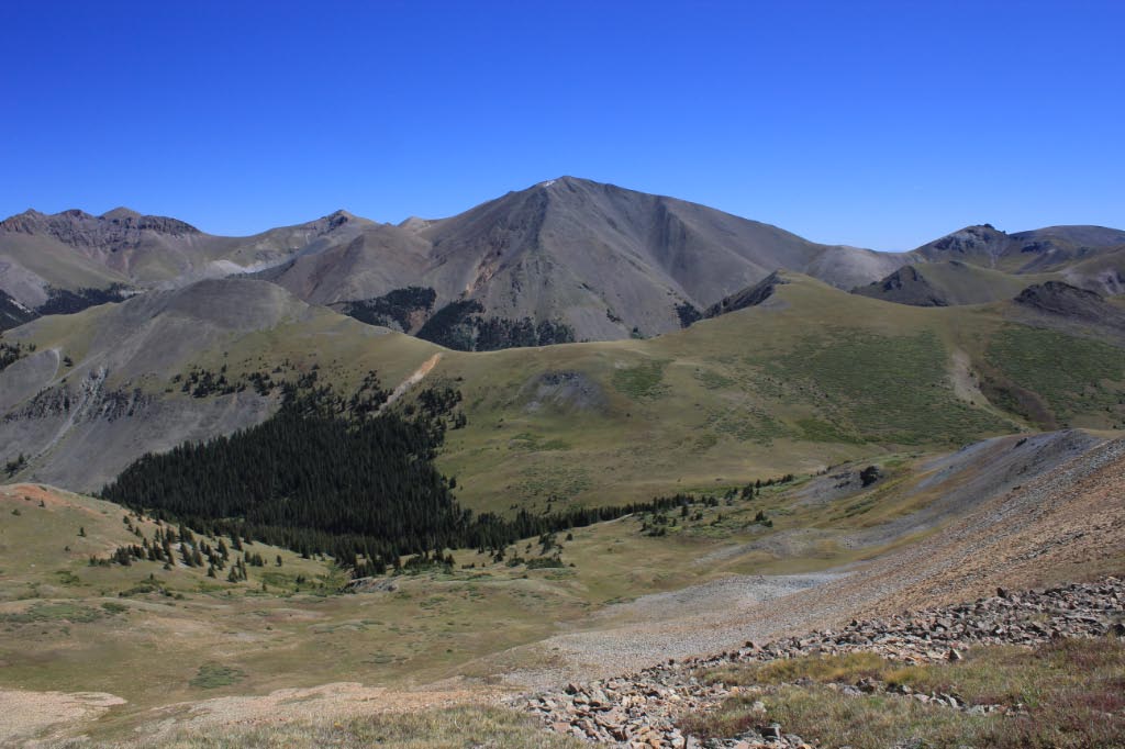
As if to top or equal yesterday, today was also a really incredible day on the trail. This area is hands down the best on the trail so far, starting with San Luis Peak and going, so I'm told, all the way to Silverton. After leaving the tree line in the morning, I didn't see another tree up close for the entire day. The trail climbs directly up to Jarosa Mesa, which is not nearly as flat or as large as Snow Mesa, but still qualifies and is really cool to walk across. I met a Denver-bound thru hiker named Maestro, who just seemed extremely happy to be hiking. He was carrying a light pack with a portable guitar strapped on the back, which is extremely cool. After a little bit I was passed by to people on mountain bikes, who were "bike packing," or carrying overnight gear. I ran into them a little bit later as well, and it sounded like they were going about the same distance I was planning for the day.


Finally I found a much needed water source, which is where a CDT thru-hiker named Boone found me. Boone passed me yesterday at about 11 am, having camped 14 miles behind me that day, and by 11 had already done around 20 miles. He arrived at the same road I did last night after dark, only he arrived around 4 pm or so and hitched into town. This guy can hike, and regularly does 30 and 40 mile days. He started on the CDT in Canada just 10 weeks ago. He's also a pretty cool guy, and gave me some energy gummies for the road. He hiked on, and I knew he would travel twice as far as I would today.


Where yesterday the trail went up and over passes and into several cirques, today it was climbing up massive flat-topped mountains, which were tilted. There must have been four or five of those before it went over Coney Summit, which is the highest point on the entire CT at 13,271 feet. The trail has been at 12,800 so many times that it hardly felt any different.


Coney Summit 13,271 feet
On the descent off of Coney Summit I ran into some problems. Despite a very confusing intersection of hiking trails and four wheel drive tracks, I was able to discern the correct way to go, where the trail and a jeep track descended towards Carson Saddle below. The problem arose when the trail turned right onto the jeep track, which was still very steeply descending for about 600 feet or so. This was a very hard packed dirt road with a fine powder dust on it, and my shoes gained absolutely no traction on it. My tread is almost completely worn off after 400 miles, and these shoes are headed for the dumpster at the end of this hike. But trying to walk on this road was like walking on a skating rink. This was the only time I actually fell on the trip so far, and I must have nearly fell at least six times. Finally I was forced to walk in the slanted tundra for about half a mile until the road leveled out again. If I had one real complaint about anything I have seen on the Colorado Trail so far, this would be it. It is silly not to cut an extra mile or so of trail to get hikers safely off of that mountain. Even with good tread this is a very slippery surface, and so unnecessary.


At Carson Saddle I ran into two guys lounging in chairs by their jeep, with a cooler nearby. I thought for sure they were there to do trail magic, but instead they had barely heard of the Colorado Trail, and seemed fascinated by my hike. Unfortunately it never dawned on either of them that a cold drink would really be the cats meow, and I was too polite to ask.

Finally the trail left that stupid slippery road, and started up a drainage towards a pass. I had about 5 miles to go, and was running out of daylight. At one point going up the pass, the trail is cut into the side of a very steep hill, with a good distance fall to the left. This is pretty common in steep areas, and some spots require caution while others have really good solid trail. This was good trail, so I was moving pretty good. All of sudden some movement caught my eye, which was a pika, a small mouse-like critter, crossing below the trail with some sort of a large flower in his mouth. I have never seen a pika carrying anything, so I stopped on the spot to watch him go. When I went to resume, my mouth went dry. Had I taken one more step, I would have stepped onto a spot where the trail was washed out, slanted steeply and consisting of that same hard pack dirt with powdery dirt on top. This little spot was only about 10 feet long, but it probably would have been enough to send me to a very nasty fall and slide. I get the impression that Someone is looking out for me down here.

It has been a day of unbelievable terrain and views, once again. The San Juan Mountains really do live up to expectations and reputation. When I got over the pass, there were simply more unbelievable mountains. Finally I arrived at an alpine lake that was my destination, and as I had guessed, the couple on the mountain bikes were there. Their names were David and Jen, and were kind enough to stay out in the freezing night to chat while I ate my late dinner. As always it is nice to camp with someone, on any trail. I have gotten to do so a handful of times now on this trail, despite the low numbers of hikers, so that is very nice.

It really is going to be cold tonight. I pulled my water filter inside and put my down jacket over me inside my sleeping bag. I'm kind of wondering if my water bottles will freeze.

Wednesday, September 1, 2010

San Luis Peak 14,014 ft


Day 27

Miles hiked today: 22.7 (20.1 CT plus 2.6 San Luis Peak)
Miles from Denver: 358.2
Elevation: 10,898 ft
Segments 20, 21
Landmarks: Continental Divide, Continental Divide Trail, San Luis Peak, La Garita Wilderness, San Luis Pass, Snow Mesa, Spring Creek Pass

VIEW MAP

I was a little worried that I wouldn't want to get out of bed at 3 in the morning, and would decide to sleep in until 9. But thankfully nature answered, awaking me with the need to pee at 2:30 am. My alarm was set for 3, so the choices were to hold it for a half hour, or get out and freeze a half hour early. So as it went, I lay there awake for a half hour.

Finally the alarm came, and I was stoked to get packed and get going. I have never climbed a 14,000 foot peak before, and climbing one in the dark before sunrise seemed an appropriate way to climb my first one. Bo was up, but then again he's in the Army so I wasn't too worried. We were packed and on the trail at 3:30 am, right on the dot. It was cold, but not as cold as I thought it would be. The night was perfectly clear, with billions of stars visible.

Because most of the elevation to San Luis' saddle had already been climbed, it didn't look that intimidating. We had camped just about 900 feet below it. Once we got up on the saddle, we were hit by a very strong wind, which was very cold. This wind was coming directly across the entire ridge, and it would be a constant enemy the entire climb up. The Colorado Trail simply goes across the saddle, and the peak itself is a side trail. We stopped at the bottom and nearly emptied our entire packs, including my heavy food bag and left everything by a bush on the ground. I was kind of hoping that the marmots wouldn't be up yet.

The climb was very steep, with many false summits. It just got colder and colder the higher we got. The wind was constant and strong, I am guessing around 30 mph. When we got to around 13,500 feet, the rocks we were walking on were covered in a heavy frost. My water bottles started to freeze, and later when I thought of it, I was extremely glad that I left my water filter down below, because if it freezes it is ruined.

Finally the last false summit was passed, and we were on the knife edge. The path was about 3 feet wide, covered in frost, with a 2,000 foot drop to either side. The summit was just beyond this, which we reached in a comfortable two and half hours from the start. This presented a bit of a problem because we were nearly a whole hour before sunrise. There was still no glow on the horizon, and every star was bright, and there was also a very bright half moon. It really was remarkable to be up that high, at that time. Thankfully somebody had built a rock wall against the wind, which we hunkered down behind, and huddled under space blankets. This is the first time I've used mine, which has travelled with me since Denver. It was just barely enough to make the cold tolerable, and every time I stood up to get a picture, the blast of frigid air would force me to sit down again.


The sun arrived right on time, revealing a world of jagged horizons in all directions. There really are mountains as far as you can see in all directions. Tall mountains. The neat thing about San Luis Peak is it stands alone as a 14er in the entire area, so it really did feel like the top of the world. With the sun came a little bit of warmth, but not near enough, and pretty soon we determined it was time to head down. This went pretty fast, and pretty soon we were back where we left our stuff, happy as larks. It was around 8 am, and the day hadn't even started. I still wanted to do 20 miles today.


So started the longest and most epic day of this entire hike. The trail had been transformed from a path through the woods to a path up and over high passes and tundra. There were barely any trees to be seen for the rest of the day, except on two occasions. I spent almost the entire day above tree line.


The trail went over one pass, and down into a cirque, then over another into San Luis Pass. This is where Bo was heading into the town of Creede to resupply and take a zero. I was still going to walk another 15 miles, even though I barely had the energy.


There were four of five more cirques in store for me, and despite my efforts I lost count. It is really hard to describe the beauty here. To be up this high, on these mountains is really magical. There are incredible views in every direction, and the weather was a perfect blue sky the entire day. This has been one of the best days of hiking I've ever experienced.


Last but not least today was Snow Mesa. This alone would have made for an incredible day, because it is like nothing I have ever seen before in my life. After walking on or near the continental divide for many hours, the trail goes up and over one last mountain, and curves around the back side. There I was treated with a view of something I've never seen before. A massive plain, elevated to 12,000 feet and nearly perfectly flat, and miles across. The trail descended to it.


The terrain on Snow Mesa is exactly like walking on the grassy plains. It turns out it's not perfectly flat, but for the most part it is, and the walk was about 5 miles across. For that entire time I was the tallest thing for miles around. Again I was very thankful for the great weather.


I was getting tired, and ready to be done with the mesa and get down to the highway at Spring Creek Pass where I planned to camp. Just when I thought the mesa would go on forever, I saw some sheep on the horizon. Hundreds of them. They were standing right near the trail, and there was a cowboy among them on horseback, with a dog. I ended up having a very nice conversation with him, whose name is David. He's tending the flock for the entire summer, which is 1,500 head of sheep. He couldn't have been older than 22, and I got the impression that he really enjoys talking to the hikers that come through here. It really was cool to see something so unusual, and put a nice cap on an extremely memorable day.


Exhausted, I made it down to the highway after dark, and found a picnic area where I planned to camp. There were already a couple of  hikers doing the same thing. It was getting cold, but I braved it to cook up some food anyhow. I was going to sleep extremely well this night.

Tuesday, August 31, 2010

The San Juan Mountains


Day 26

Miles hiked today: 14.2
Miles from Denver: 338.2
Elevation: 11,720 ft
Segments 19,20
Landmarks: Continental Divide Trail, Gunnison National Forest, Chochetopa Creek, La Garita Wilderness, Eddiesville Trailhead

VIEW MAP

I woke up this morning with a lot of dew on my tent, and a slight frost. It is getting colder, and I have a feeling its going to be that way for a while. I was pretty late in waking up, and while I was eating breakfast the sun actually came over the nearby mountain and shined directly on me. It was nearly 9 oclock.


This didn't really follow my plans for the day, which involved waking up early so that I can get 15 miles done by early afternoon, so that I could summit San Luis Peak today. San Luis Peak is 14,014 feet tall, and is one of only a handful of 14ers that are easily accessible from the trail. I have passed all the others.

Today was just one of those days where the miles slowly ticked by, while time went faster than it should. By noon I had only done 6 and a half miles, and I found myself at Eddiesville Trailhead stopping for a snack, seemingly in slow motion. 2 hours later I had only moved about 2 miles, having stopped in a beautiful meadow to soak in the sun, eat some food and dry my stuff out. San Luis was not going to happen today.


A few miles earlier I had entered La Garita Wilderness area, which is the 5th Wilderness Area the trail has come though. After these last several segments of hiking on jeep roads, I was very excited for some pristine trail untouched by motorcycles and ATVs. What's interesting is that even in the wilderness area, I was still seeing double rut tracks.

The trail at this point is following Chochetopa Creek to its source, which is what I did for the whole day. The river valley is lined on either side with an ever more impressive array of mountains the farther up the valley I travelled. According to my map I have officially arrived in the San Juan Mountains, which is what I have been looking forward to this entire trip. If this introduction is any indication, they are absolutely beautiful. But I have the feeling I haven't seen anything yet.


I had decided to stop just before the climb up to San Luis Peak, and summit in the morning. That is going to make tomorrow a very long day. As I got closer to the head of the valley, the trail became enclosed in a very ancient forest. Most of the forests I've seen in Colorado, or even in most states I've been to, have already been logged and replanted. Some of the forests on the Colorado Trail are 3rd generation, having been logged and replanted twice. This forest however, doesn't seem like its ever been touched. This is the most remote part of the entire Colorado Trail, and is also the least used by even hikers.


About a quarter mile before I reached my intended camp site I met another hiker named Bo, who was already set up for the night and was about to build a fire. It was early, maybe 5 pm. Bo explained that the camp site listed was out in the open, which would be a concern with the cold wind coming off the pass. I decided to set up my tent at his camp, and enjoy a fire for the first time on this trip, as well as some rare company.

It was very nice having a fire, and we traded stories over the campfire until after dark. Bo explained his plan to hike San Luis Peak not in the morning, but the middle of the night so that he could get up there just before sunrise. This sounded intriguing. I had done something crazy like this once before; my middle of the night hike of Blood Mountain on the AT, and was greatly rewarded with one of the most unforgettable sunrises I have ever seen. I was in. We figured that a 3:30 am start would be needed, and I turned in to my tent for what was to be a very short night, and a very long day.

Monday, August 30, 2010

Chochetopa Park


Day 25

Miles hiked today: 21.2
Miles from Denver: 324
Elevation: 9,720 ft
Segments 18, 19
Landmarks: Continental Divide Trail, Gunnison National Forest, Chochetopa Park, Chochetopa Creek

VIEW MAP

It was very hard to get out of Gunnison. I ended up spending two zeroes there. Yesterday I actually tried to leave, but I stood by the highway for over an hour and didn't get picked up. That kind of killed my motivation to hike that day, and I ended up wandering across the street into the Pioneer Museum, and ended up spending several hours there. I can highly recommend this museum, by the way.

So I found myself this morning, motivated to put some miles down, and anxious to get going, getting soaked by a rain storm on an errand I was running. This was not a good way to start the day. I ended up stalling a little longer indoors until the rain stopped, and finally I was out the door by 11. Not exactly an early start, but at least I was dry.

I had to travel over 40 miles to get back to the trail, which is first 8 miles east on Rt 50, a very busy highway, and then 33 miles south on Hwy 114, which almost nobody travels. This could be a very long wait. Within a half hour I caught my first ride, a nice guy named Brian who was literally on his way to the airport to fly to Patagonia for a 1 year NOLS training course, which is National Outdoor Leadership School. When he comes out of that course he should be able to eat thru hikers for lunch.

The second ride I caught was from a guy named Jesus, who is a carpenter. No kidding. He pronounces his name (Hey-Soos), and he was just talking about his work on the way up, so I wasn't really thinking about it at the time. It wasn't until I got on trail that it dawned on me that I had just gotten a ride from Jesus the carpenter. The nice thing was that before I got in the car, he discussed that he was going 35 miles on Hwy 114, which worked for me because I was only going 33. However, when he dropped me off at the pass, he drove off the way we had just came, so I think we passed his work site and he didn't say a word.


I finally got on trail at 12:30 pm, which is not exactly early. I am trying to make it to Silverton in 5 days, which is 106 miles away. This means that I planned to go at least 20 miles each day, and I was a little worried now. I have a 3 mile an hour pace when I really hurry, and once, on the AT I had gone 21 miles in exactly 7 hours. I never thought I would try it again on this hike, but there is no time like the present. The terrain is flat, and is supposed to be easy walking. 21 miles also happens to be how far it is to the next reliable water source. I started out at a brisk pace.

Not a half mile from the road, I came upon some trail magic. A guy named Burnfoot had stocked two coolers with soda, and there was a register there as well to sign in. The register was full of fun anecdotes, and high praise for burnfoot leaving these sodas here. Had I not been in town for nearly three and a half days the soda probably would have tasted much better to me, but I am extremely thankful all the same, and especially on this trail which is barren on trail magic, this is very welcome. Packing a root beer with me, I was also able to go the entire day without needing water.


The guidebook talks about this being one of the most scenic segments of the whole trail, but at first I just wasn't getting it. I was on roads of some sort or another the entire day. There are forest service roads, fire roads, county roads, jeep tracks and hunting roads. Not a bit of trail, and all of it accessible to horses, mountain bikes, motorcyles, ATVs and any other kind of vehicle you want to bring. This is a far cry from the footpath-only regulations I know and love, but this is offset by the fact that I didn't see a soul of any means of transport, all day.


About halfway through the afternoon I came upon the scenic part. I have learned that in Colorado, a park is what you call a vast, open space in the mountains. Chochetopa Park is such a place, and it is very impressive. It goes for as far as I could see, and is dotted with small stands of trees, with a plateau on one side, and tree covered hills on the left. At the far horizon there are some mountains, but these are so far away that they looked very tiny. This is ranch country, and a barbed wire fence cuts through the scene, until I couldn't see it any more. It is kind of like walking through a smaller version of Shirley Basin.


The trail takes about six miles to get across this, and it is a very scenic, and windy walk. I had beautiful weather, but I would not want to walk across this when it was cold, windy, raining or snowing. Eventually I got to a road, where the trail turned left on the road, up into the hills. There was still much more to Chochetopa Park.


It was getting late in the day now, and I could see that I had nearly enough time to make the 21 miles, but I
would be finishing up in the dark. Sunset came, and I was able to use the light from the sky to hike until nearly an hour past sunset. In the last couple of miles, the trail climbs 600 feet on a jeep road, then turns downhill to meet up with Chochetopa Creek. It was now nearly completely dark, but there was just enough light to shine off of the rocks, of which there were many. I was hurrying, as I wanted to get to camp and set up before any weather could set in, as there were a few dark clouds overhead. My feet moved swiftly, uncannily finding all the spots where there were no rocks, never kicking or tripping on one. I have experienced this phenomenon once before, but I have never been as sure footed when hiking as I was just now, despite barely being able to make out the contours of the trail, much less where all the rocks are. It is a really strange sensation. I flew down the hill, and finally in the last mile I was forced to stop and dig for my headlamp, as mists of rain started falling.

Luckily, the weather moved on as I found a campsite next to a gurgling creek and set up my tent. It's the worst job of setting up my tent I've done yet, and the thing sagged in crucial places. I would be very grateful if it doesn't rain on me tonight.

Friday, August 27, 2010

Gunnison


Day 22

Miles hiked today: 13.1
Miles from Denver: 302.8
Elevation: 9,680 ft
Segment 17
Landmarks: Continental Divide, Continental Divide Trail, Razor Creek, Lujan Creek, Gunnison National Forest, Rio Grande National Forest, Gunnison

VIEW MAP

Last night I contemplated making an escape off trail into Gunnison or back to Salida, on Rt. 50. I should have taken a zero in Salida, and my body is suffering for it. I have 40 miles to go to Creede, and not sure I can make it.

This morning I put all thoughts out of my head, as I was feeling better and figured the night's rest had fixed me up. I packed up and, stupidly, didn't fill my water bottles at the lake because the guidebook says there is water 3.5 miles ahead, at Razor Creek. I had about a 300 foot climb to get back to the trail, and didn't want to carry the weight. I planned on stopping for breakfast at the creek, but there wouldn't be another water source for another 9 miles after that.

Soon I encountered Thumbs Up, who had camped a little behind the turn for the lake and got going a little earlier than I did. I told him I would see him at breakfast, and pushed on.

Soon I passed a sign for the Razor Creek trail, and then a dry creek bed. Uh-oh. According to the map, this was Razor Creek, and it was dry. Thumbs Up arrived, and we put our two different maps together and determined that we were in the right spot, and there was no running creek. About a quarter mile back, uphill, there was a small little puddle where the creek crossed the trail. That was the only water for miles.

One of my all-time favorite pieces of gear has to be my Platypus water tank, which is a plastic water bag that holds 4 liters and has handles. I use it every time I filter water, putting the water first in the bag, then filtering out of the bag. This allows me to avoid putting my filter intake down in the mud, and also allows me to move the water to a comfortable sitting place so that I can pump the filter. This came in very handy just now, and before long I had two water bottles full of clear but slightly strange tasting water. It would have to do.

I told Thumbs Up about my thoughts about taking a break from the trail, and he had an overview map of Colorado and pointed out that the upcoming highway could take me to Rt. 50, and then to Gunnison. I was still feeling like I could make the next 40 miles into Creede, and told him it was just something I was thinking about.

The trail sticks pretty close to the Divide right here, which means that there is a lot of climbing and descending. Pretty soon it descended to a place called Lujan Pass, which looks like it was settled at one point, and has several spots that bear the evidence of long-ago standing buildings. The trail joins a forest road from there, and descends off the divide and down to the highway. It is also near the 300 mile mark.


As the road went down, it followed Lujan Creek which was not much more than a trickle in spots, an underground creek in others. There was thick brush or rocks in many spots preventing access, but finally I found a spot that had a nice resting spot and had access to a small flow of water. This would be the last water source for the next 20 miles of trail, potentially. I stopped and cooked my dinner as my lunch so that I wouldn't need water to cook later, and filled up my extra water bag for the long haul.

When I got going again, just a mile from the highway, I changed my mind. I was going to be suffering a lot over the next several days if I didn't take a rest, like I should have. Gunnison was about 40 miles away, but just a thumb on my part. I left Thumbs Up a note explaining my absence, and hitched into town. A very nice guy named George stopped, who commutes once a week on this road, every Friday, from San Louis to Montrose, which takes him through Gunnison. I was very fortunate he stopped, because this should be a near impossible hitch, on a road that isn't supposed to have any traffic. He said he had once picked up a thru hiker, which is why he stopped for me. He had a cooler with soda and peaches, and bid me to help myself. Hwy 114 travels for 33 miles through an unbelievable rocky red canyon, and George said there are over 500 Big Horn Sheep that live in it. Sure enough, we spotted some and we got out of the pickup to get a better look, and he had a pair of binoculars. Overall it was a nice bit of trail magic, to find such a ride in such a place, with someone who only comes that way once a week. Thanks George!

So I'm all set for a day off, and I will pick up where I left off on Sunday. Now I should be able to get all the way to Silverton without stopping in Creede or Lake City, a distance of 108 miles. I've hiked such a distance once before, in Maine's 100 Mile Wilderness, which has a great and famous sign at the start, warning hikers not to enter unless they are carrying at least 10 days of supplies. This is always a humorous photo stop for a thru hiker. I'll carry 5 days worth.