Showing posts with label Mt. Guyot. Show all posts

Thursday, August 12, 2010

Georgia Pass


Day 7

Miles hiked today:  23
Miles from Denver: 101.2
Elevation: 9,400 ft
Segment 6
Landmarks:  Georgia Pass, Continental Divide, Continental Divide Trail, Mt. Guyot, Keystone Ski Area

VIEW MAP


Wow.  23 miles today, two big climbs and two storms I'll never forget.  Where should I start?


I think that I could have actually made it over the pass yesterday, but it would have been a very long day.  All indications were there for a clear evening, and now I know that there are campsites much closer on both sides.  I awoke this morning to the sound of heavy winds, and only half the sky was clear.  It was about 6:30 AM.  Within a few minutes, I was driven back into my tent because of rain.  This was going to be an interesting day on the pass.  I decided that when the rain quit I would skip breakfast and boogie as fast as I could.  I had 6 miles and about 1,800 feet to climb, the last three quarter miles of that above tree line, and probably a quarter mile off the other side before re-entering tree line.  That mile at the the top is where you don't want to be when a storm hits.


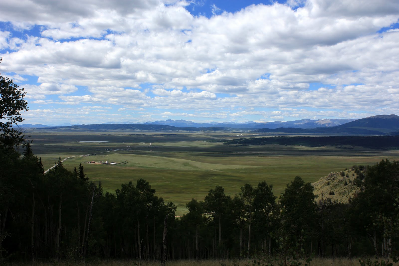
I made pretty good time getting up to the Divide, and the views were breathtaking.  It is one thing to look at these mountains from far away and be in awe; it is quite another to approach them, walk past them, and see how they look different from every angle.  There were a whole row of peaks, all connected by "knife edge" walls of rock.  There were tiny glaciers still in place on some of them.  One was all red, probably due to iron deposits.  Mt. Guyot stands above them all, the guardian of Georgia Pass.  The pass itself is surprisingly tame in comparison.  Approaching it, you are above tree line only briefly, and there is still grass and hardy plants growing at the pass.  The pass is  at 11,860 feet.  If you look at a distance, there is this surprisingly low spot off the right shoulder of Mt. Guyot.  That is why settlers first noticed it and used it, and it became the gateway for thousands descending on Leadville and Breckenridge during the silver rush.  In fact the old road that their wagons would have used still exists, and I crossed it today.


My timing was perfect.  I had breathtaking views of Mt. Guyot and the other peaks in the divide all the way up, and as I crested the rise I was treated with my first view of the Tenmile Range, which I will be on in a couple of days, and what seemed to be the rest of Colorado.  That is, a view of the Tenmile Range with those distinctive tall, dark clouds preceded by rolling pin shaped clouds.  I was about to be in a bit of trouble.  In as much time as it took me to eat a snickers bar and snap some photos, those lead clouds hurdled the Breckenridge Valley below, and I could see the grey wisps of rain enveloping the flanking peaks of Mt. Guyot.  It was a strange sight because the sun was still out behind me, and Guyot was illuminated beautifully by the sun, framed by an ugly grey cloud that was about to swallow it whole.  That was my last picture, as I struggled to put my camera into its ziplock baggie on the run.  There was no thunder or lighting, just all wind and rain, like a freight train.  I had noticed that the trees were not very far, but what I failed to notice is that the trail went first across the rim of the pass to the far end before entering them.  It was probably 120 yards, and I didn't make it before getting slammed with ice cold rain drops traveling sidewards at what seemed to be 40mph.  Thank God I put that camera away when I did, or it would have been toast.  In a matter of moments I was soaked head to toe, and I could tell it was cold enough to cause me some problems if it lasted much longer than say, 20 minutes.  I looked over my shoulder and Mt. Guyot was gone, swallowed by the grey mass.  I made it to tree line ok, and after about 15 minutes the storm died down, and the sun came out.  I found a nice campsite with direct sun, and in no time myself and all my gear were basking in 80 degree sun.


Walking down the other side of the pass, I was greeted with views of mountains I hadn't yet seen far off in the distance, having traded those that are behind on the other side of the pass.  The guidebook here explains that the trail used to just run along a dusty dirt road with lots of traffic, and they were finally able to re-locate it up the side of a mountain.  What this really means is that they put in another big climb up the west ridge of Keystone Ski Area, about half as big a climb as the pass itself.  I was feeling good however, and it was early in the afternoon so I took the plunge.  On top of this ridge I was caught in another storm, this time a hail storm.


Yet again the storm dissipated and the sun came out, and before long I was coming up on my intended camp site.  The problem was, the guidebook says there is water here and I didn't see any water.  So I kept walking, another 3 miles, pushing my day into the long and very tiring category.  I climbed yet another hill, and back down the other side before coming to Horseshoe Gulch.  There was water but no campsite! Very tired now, I filled my water carrier with 4 liters and trudged up yet another hill, until I found a campsite about a half mile up.


It turned into a very nice evening, and once I got settled I was very happy.  The longest day yet, and my feet felt fine.  I was now just 4 miles from the road that would take me into Breckenridge and civilization, and I was very much looking forward to a shower and a very large plate of food.

Wednesday, August 11, 2010

Kenosha Pass


Day 6

Miles hiked today:  10.1
Miles from Denver: 78.2
Elevation: 10,000 ft
Segments 5,6
Landmarks:  Kenosha Pass, Jefferson, Mt. Guyot, Jefferson Creek

VIEW MAP


I rose early after the first rainless day and night so far.  There was not even a dew covering my tent, and it was nice to put it away dry.  I ate a light breakfast because I was headed in to town, and packed up quickly.  My camp site had a view of the Continental Divide, and the peaks were already lit up when I set out at 6:30 AM.


It was chilly but just the right temperature for a brisk walk.  I wanted to get down to the road early because who knew how long it would take to catch a ride.  It is one of those experiences that every thru-hiker knows well: the suddenly hyper-attuned ear for the sound of the highway on a town day.  In this case I could actually see the tiny hamlet of Jefferson from far away as early as yesterday; it looked to have maybe a dozen buildings with ranches spread out in all directions, and a huge snow fence striking a tan line to the northwest of town.  I could see tiny cars zipping in and out of town on US 285, which would soon take me there as well.  But this was only what I could see from the vistas from far away, as I got closer I was enveloped by woods but my ear picked up the sound easily of the busy highway of trucks and cars, drawing steadily closer.


Kenosha Pass has seen generations of travelers use it to access the interior mountain ranges of the Colorado Rockies.  There are still some railroad tracks preserved from the Denver, South Park and Pacific line that ran here from Denver until the 1920's.  The switchyard was actually right at the crest of the pass, utilizing the flat ground there.  You could catch a train from Denver to Breckenridge in just 6 hours, and there were 3 competing rail companies that ran to different parts of the Rockies.  All 3 went under due to a combination of the silver market dissipating, the trucking industry and the great depression.  It is strange that building something like that seems so out of reach to us today.


Hitch hiking is simply a part of life on a long distance trail.  I don't really know anybody who truly enjoys it, and it is always an anxiety filled experience for both hiker and driver.  For me it is the prospect of standing by the road for hours as car after car whiz by that gives me the most anxiety.  Some of them actually wave as they drive past!  It is harder to do if you are male, and have a scraggy beard.  Being alone doesn't help either.  If there are two people I think you are better off, but 3 might be too many for most seating situations.  What helps most of all is if one of the party is female.  Here, let's play multiple choice: 1. scraggy beard guy alone, 2. two scraggy beard guys, 3. scraggy beard guy with non-bearded female, or 4. two non-bearded females.  Now which of the above combinations would you put in your Subaru Outback?  The amazing thing to me was that this is Colorado, and therefore half of all vehicles are pickup trucks, yet they still weren't stopping.  Pickup beds are the PERFECT place to throw dirty hikers.  You don't even have to talk to them or worry if they're going to mug you for ramen.  Just pull over at the destination and give one of those waves out the open window.  I saw one pickup that had three tough looking cowboys inside.  Comon, what's to be afraid of boys?  Think I'm going to steal your fence post digger?  I will say that us hikers have an advantage over our homeless or otherwise drifter type hitch-hiking brethren: the trail.  That is, there is a completely legitimate reason that I am standing by the side of the road with my thumb out, and that is that I'm hiking to freakin Durango and my car is otherwise inaccessible at the moment.  This means that in theory, there are people who understand that the Colorado Trail exists, crosses where I am standing, and that hikers often need rides might put all of those clues together when they see I am dressed the part, plus make a split second decision on whether I look too creepy or too dirty, all within enough time to slam on the brakes before the 50 yard pull over area runs out.  It's a great theory, but it works a whole lot better in Vermont.  I even stood by the "Colorado Trail Parking" sign and gave a whole lot of room for cars to pull over, and still saw probably 100 cars go by in a half hour.  I got plenty of shocked looks, especially from older people.  Some of the faces were priceless.  Some people pointed.  Several were texting or on their phones and didn't even see me.  One woman who was standing in the parking lot behind me took a picture.  I'm sure I strike a cutting figure with my pack on and thumb out against that Colorado blue sky.  And one guy waved.  Please, don't be THAT guy.


Finally a semi pulled over, and I was thrilled to ride in my first semi truck.  As I sprinted the 50 yards or so to the cab, I found it locked.  I walked around, only to find the driver checking his brakes for the descent down the pass.  He can't take riders.  Ok. Ultimately a local guy I was chatting with earlier as he was gearing up his mountain bike came back from his ride.  He was about my age and seemed like a pretty normal guy.  I asked if he wouldn't mind giving me a ride, and he was nice enough to do so, even though it was out of his way.  Bo was his name I think, and he had even done some long distance hiking himself.  So, score one for trail magic today!


The town of Jefferson is quite nice.  It is probably even smaller than Stratton, Maine, and has all trail towns I've ever been to beat; you only need to go to one place. Jefferson Market it's called, and inside is made to order food, groceries, homemade cinnamon rolls, and tucked in one corner behind a window is the post office.  The people there were super friendly, and there were 5 locals sitting down chatting over coffee.  This was my kind of place.  There was just one problem however, that is on Tuesdays and Wednesdays the kitchen is closed because they are making fudge.  Just my luck.  All was well however when one of the ladies (really wish I could remember names better) brought me to the back deep freezer, which was full of all kinds of frozen burritos, frozen chimichangas, frozen hot pockets, frozen egg sandwiches, etc.  I grabbed several of those, and one of those cinnamon rolls and all was right with my world.  My mail drop had arrived, which was the whole point anyways and I was now set for the next several days until Breckenridge.  I caught a ride back to the trail by asking a local guy (they said he runs the bake shop across the street).  He didn't look too thrilled, but it's just a 10 minute round trip and I think that people, when asked, find kindness in their hearts.  Or pity.


Back to the trail.  I was very excited to run into two actual thru-hikers, going towards Denver.  They weren't just any thru-hikers either, they were Appalachian Trail thru-hiker alumni.  They were a couple, it sounded like they met on the AT several years ago.  I know for sure the guy's name was Six Two, and the girl's was E-something.  Dang.  Names!  (guys if you want to sign into my guestbook and set me straight on this I'll edit this post)  Anyways it was a lot of fun to stop and chat with them, and we passed a lot of time talking about gear we used in the 90's, how to hike with an umbrella, and the fact that Six Two carries all of their food in a battleship of a pack.  It was fun to reminisce, and made me wish there were at least a few hikers going my way that weren't hiking twice my speed, or half my speed.  Ah well.  A few miles later I ran into another thru-hiker who had come from Durango in about 3 weeks time.  She confirmed that there were waves of 15-20 thru-hikers per day several weeks ago.


I pulled up way short today because I am about to cross the Continental Divide, which is 6 miles from the last place I could camp.  The next camping spot on the other side is another 7 miles beyond that.  So, a 10 mile day or a 23 mile day.  I'll be ready for those 23 and 25 mile days soon, just not this day.