Showing posts with label Continental Divide Trail. Show all posts

Friday, September 3, 2010

The Grenadiers


Day 29

Miles hiked today: 20.2
Miles from Denver: 401.3
Elevation: 10,320 ft
Segments 23, 24
Landmarks: Continental Divide, Continental Divide Trail, Cuba Gulch, Minnie Gulch, Headwaters of the Rio Grande, Stony Pass, Weminuche Wilderness Area, The Grenadiers, Elk Creek

VIEW MAP

It is hard to believe, but this just gets better by the day. These 60 miles or so have to be some of the best trail in America. The weather has been absolutely phenomenal, as I haven't seen a threatening cloud since Monday. I also haven't seen a tree up close for nearly two full days of hiking, as the trail spends nearly 33 miles above tree line.


I woke up this morning to a very cold and frosty world. There was heavy frost coating my tent, due to the condensation freezing. My bottles hadn't froze, but when I got some water out of the pond, ice started to form. It was about 7 am, and very cold to be up, but I wanted to eat breakfast here while I had the water source. The worst part was packing away a frosted tent into a stuff sack with bare hands. It took my hands at least 10 minutes to recover from that.

I was up and ready before David and Jen were barely out of their tent, so I bid them goodbye and started on. Immediately I was climbing up a pass, into another set of mountains, then over another pass and into another. This repeated over and over again, and it never failed to astonish me that there were yet more incredible mountains over the next pass. The trail was following the Continental Divide as closely as it could, hence why it was going over all of the passes.


Finally the trail dropped down into a drainage to the left, which it turns out, is the headwaters for the Rio Grande. Curving around the side of a mountain, the trail joins Stony Pass road for a short spell before heading due south into the Weminuche Wilderness Area. (pronounced Whe-Me-Nooch) This is the sixth and final wilderness area that the CT passes through, which is yet another reminder that I am nearing the end. This is the last stretch of trail that the CT will be on the Continental Divide, and I am certainly going to miss it.


The area south of Stony Pass certainly had a little different character. I'm not quite sure how to describe it, other than it feels more southwest. There are more rocks than north of here, and a lot of the mountains are composed of different stuff. The trail is again following the Continental Divide as closely as it can. Pretty soon came the sign I had been waiting for, which directs the Continental Divide Trail south towards Mexico, and the Colorado Trail to the west. This is the last time I'll see the CDT on this trip.


The Colorado Trail immediately turns up on the Continental Divide itself after that sign, for one last glorious half mile on the Divide. This was probably my favorite spot of all the miles I spent up on the Divide on this trip. The trail was up on a grassy hill, which would have been suitable for a soccer game. It really reminded me of Max Patch on the Appalachian Trail. In all directions were breathtaking mountains, but due west was the most breathtaking view I have seen thus far; the jagged rock towers of the Grenadier Range, standing sentinel over Elk Creek a thousand feet below. The late afternoon sun glimmered off of the creek, as well as the quartzite surface of the Grenadier peaks. The creek disappeared into a black canyon of incredible scale. And right next to me was a sign saying that I was to descend down that canyon.


Of all the breathtaking views and mountains I have seen over the last four weeks, this one takes the cake. What's more is that I had been hoping this to be the case, after reading a short description on the Grenadier range, but mostly just because I thought the name was extremely cool. If the trail ended in Silverton, 13 miles from here, I could be happy. This is a truly incredible place.

Getting down to Elk Creek was quite a trick. Very aware that my shoes are prone to slip, I gently navigated the over 20 switchbacks that bring the trail nearly a thousand feet down a steep grassy slope. From here the trail follows Elk Creek in a nearly four thousand foot, 8 mile drop to the Animas River. This is definitely a little different scenery than what I've been seeing for the last 3 days.


I decided to stop with a little bit of daylight left for a change, and I will make an early run for the post office in Silverton. I still have about 10 miles to go tomorrow, which includes a two thousand foot climb. I am very excited to be so close to the last resupply town, and the last leg of the trail. I plan to be in Durango on Wednesday, and life will swiftly return to normal. But I am in a very good mood after the last several days of Middle Earth-ish terrain, and I can't wait to see what the last four segments of the trail have in store. Tomorrow is a town day, which means beer, pizza and a hot shower. That makes me extremely happy too.

Thursday, September 2, 2010

Carson Saddle


Day 28

Miles hiked today: 22.9
Miles from Denver: 381.1
Elevation: 12,250 ft
Segments 22, 23
Landmarks: Continental Divide, Continental Divide Trail, Jarosa Mesa, Antenna Summit, Coney Summit, Carson Saddle, Cataract Lake

VIEW MAP

I was anxious to get moving quickly this morning, both because it was very cold and because I planned to do a lot of miles. There was frost on the ground, and I think I can expect the temperature to start to drop over the next week or so that it takes me to finish this trail.

I am trying to make it to Silverton by Saturday morning, because the post office has some stuff that I sent there, the most important of which being my camera battery charger. I thought I would be clever and save some weight by mailing it ahead, and now it will drive me to do extra miles each day and race the post office hours. This upcoming weekend is Labor Day weekend, so if I miss the P.O. on Saturday, I would have to wait until Tuesday or do without. The one thing I absolutely don't want to happen on this trip is to run out of battery in my camera.


So I started out at 7:30, counting on a listed "good water source" 2.5 miles in for my breakfast. That water source never materialized, and neither did my breakfast. I did see a bobcat however, and watched him stalk me through the grass for about 10 minutes. He never did get very close, and at one point I moved and he spooked.

As if to top or equal yesterday, today was also a really incredible day on the trail. This area is hands down the best on the trail so far, starting with San Luis Peak and going, so I'm told, all the way to Silverton. After leaving the tree line in the morning, I didn't see another tree up close for the entire day. The trail climbs directly up to Jarosa Mesa, which is not nearly as flat or as large as Snow Mesa, but still qualifies and is really cool to walk across. I met a Denver-bound thru hiker named Maestro, who just seemed extremely happy to be hiking. He was carrying a light pack with a portable guitar strapped on the back, which is extremely cool. After a little bit I was passed by to people on mountain bikes, who were "bike packing," or carrying overnight gear. I ran into them a little bit later as well, and it sounded like they were going about the same distance I was planning for the day.


Finally I found a much needed water source, which is where a CDT thru-hiker named Boone found me. Boone passed me yesterday at about 11 am, having camped 14 miles behind me that day, and by 11 had already done around 20 miles. He arrived at the same road I did last night after dark, only he arrived around 4 pm or so and hitched into town. This guy can hike, and regularly does 30 and 40 mile days. He started on the CDT in Canada just 10 weeks ago. He's also a pretty cool guy, and gave me some energy gummies for the road. He hiked on, and I knew he would travel twice as far as I would today.


Where yesterday the trail went up and over passes and into several cirques, today it was climbing up massive flat-topped mountains, which were tilted. There must have been four or five of those before it went over Coney Summit, which is the highest point on the entire CT at 13,271 feet. The trail has been at 12,800 so many times that it hardly felt any different.


Coney Summit 13,271 feet
On the descent off of Coney Summit I ran into some problems. Despite a very confusing intersection of hiking trails and four wheel drive tracks, I was able to discern the correct way to go, where the trail and a jeep track descended towards Carson Saddle below. The problem arose when the trail turned right onto the jeep track, which was still very steeply descending for about 600 feet or so. This was a very hard packed dirt road with a fine powder dust on it, and my shoes gained absolutely no traction on it. My tread is almost completely worn off after 400 miles, and these shoes are headed for the dumpster at the end of this hike. But trying to walk on this road was like walking on a skating rink. This was the only time I actually fell on the trip so far, and I must have nearly fell at least six times. Finally I was forced to walk in the slanted tundra for about half a mile until the road leveled out again. If I had one real complaint about anything I have seen on the Colorado Trail so far, this would be it. It is silly not to cut an extra mile or so of trail to get hikers safely off of that mountain. Even with good tread this is a very slippery surface, and so unnecessary.


At Carson Saddle I ran into two guys lounging in chairs by their jeep, with a cooler nearby. I thought for sure they were there to do trail magic, but instead they had barely heard of the Colorado Trail, and seemed fascinated by my hike. Unfortunately it never dawned on either of them that a cold drink would really be the cats meow, and I was too polite to ask.

Finally the trail left that stupid slippery road, and started up a drainage towards a pass. I had about 5 miles to go, and was running out of daylight. At one point going up the pass, the trail is cut into the side of a very steep hill, with a good distance fall to the left. This is pretty common in steep areas, and some spots require caution while others have really good solid trail. This was good trail, so I was moving pretty good. All of sudden some movement caught my eye, which was a pika, a small mouse-like critter, crossing below the trail with some sort of a large flower in his mouth. I have never seen a pika carrying anything, so I stopped on the spot to watch him go. When I went to resume, my mouth went dry. Had I taken one more step, I would have stepped onto a spot where the trail was washed out, slanted steeply and consisting of that same hard pack dirt with powdery dirt on top. This little spot was only about 10 feet long, but it probably would have been enough to send me to a very nasty fall and slide. I get the impression that Someone is looking out for me down here.

It has been a day of unbelievable terrain and views, once again. The San Juan Mountains really do live up to expectations and reputation. When I got over the pass, there were simply more unbelievable mountains. Finally I arrived at an alpine lake that was my destination, and as I had guessed, the couple on the mountain bikes were there. Their names were David and Jen, and were kind enough to stay out in the freezing night to chat while I ate my late dinner. As always it is nice to camp with someone, on any trail. I have gotten to do so a handful of times now on this trail, despite the low numbers of hikers, so that is very nice.

It really is going to be cold tonight. I pulled my water filter inside and put my down jacket over me inside my sleeping bag. I'm kind of wondering if my water bottles will freeze.

Wednesday, September 1, 2010

San Luis Peak 14,014 ft


Day 27

Miles hiked today: 22.7 (20.1 CT plus 2.6 San Luis Peak)
Miles from Denver: 358.2
Elevation: 10,898 ft
Segments 20, 21
Landmarks: Continental Divide, Continental Divide Trail, San Luis Peak, La Garita Wilderness, San Luis Pass, Snow Mesa, Spring Creek Pass

VIEW MAP

I was a little worried that I wouldn't want to get out of bed at 3 in the morning, and would decide to sleep in until 9. But thankfully nature answered, awaking me with the need to pee at 2:30 am. My alarm was set for 3, so the choices were to hold it for a half hour, or get out and freeze a half hour early. So as it went, I lay there awake for a half hour.

Finally the alarm came, and I was stoked to get packed and get going. I have never climbed a 14,000 foot peak before, and climbing one in the dark before sunrise seemed an appropriate way to climb my first one. Bo was up, but then again he's in the Army so I wasn't too worried. We were packed and on the trail at 3:30 am, right on the dot. It was cold, but not as cold as I thought it would be. The night was perfectly clear, with billions of stars visible.

Because most of the elevation to San Luis' saddle had already been climbed, it didn't look that intimidating. We had camped just about 900 feet below it. Once we got up on the saddle, we were hit by a very strong wind, which was very cold. This wind was coming directly across the entire ridge, and it would be a constant enemy the entire climb up. The Colorado Trail simply goes across the saddle, and the peak itself is a side trail. We stopped at the bottom and nearly emptied our entire packs, including my heavy food bag and left everything by a bush on the ground. I was kind of hoping that the marmots wouldn't be up yet.

The climb was very steep, with many false summits. It just got colder and colder the higher we got. The wind was constant and strong, I am guessing around 30 mph. When we got to around 13,500 feet, the rocks we were walking on were covered in a heavy frost. My water bottles started to freeze, and later when I thought of it, I was extremely glad that I left my water filter down below, because if it freezes it is ruined.

Finally the last false summit was passed, and we were on the knife edge. The path was about 3 feet wide, covered in frost, with a 2,000 foot drop to either side. The summit was just beyond this, which we reached in a comfortable two and half hours from the start. This presented a bit of a problem because we were nearly a whole hour before sunrise. There was still no glow on the horizon, and every star was bright, and there was also a very bright half moon. It really was remarkable to be up that high, at that time. Thankfully somebody had built a rock wall against the wind, which we hunkered down behind, and huddled under space blankets. This is the first time I've used mine, which has travelled with me since Denver. It was just barely enough to make the cold tolerable, and every time I stood up to get a picture, the blast of frigid air would force me to sit down again.


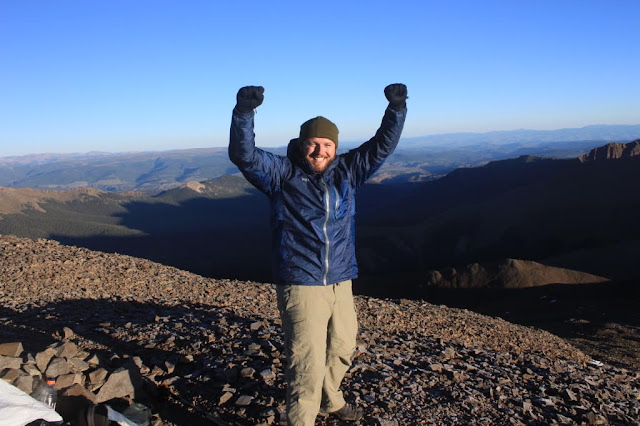
The sun arrived right on time, revealing a world of jagged horizons in all directions. There really are mountains as far as you can see in all directions. Tall mountains. The neat thing about San Luis Peak is it stands alone as a 14er in the entire area, so it really did feel like the top of the world. With the sun came a little bit of warmth, but not near enough, and pretty soon we determined it was time to head down. This went pretty fast, and pretty soon we were back where we left our stuff, happy as larks. It was around 8 am, and the day hadn't even started. I still wanted to do 20 miles today.


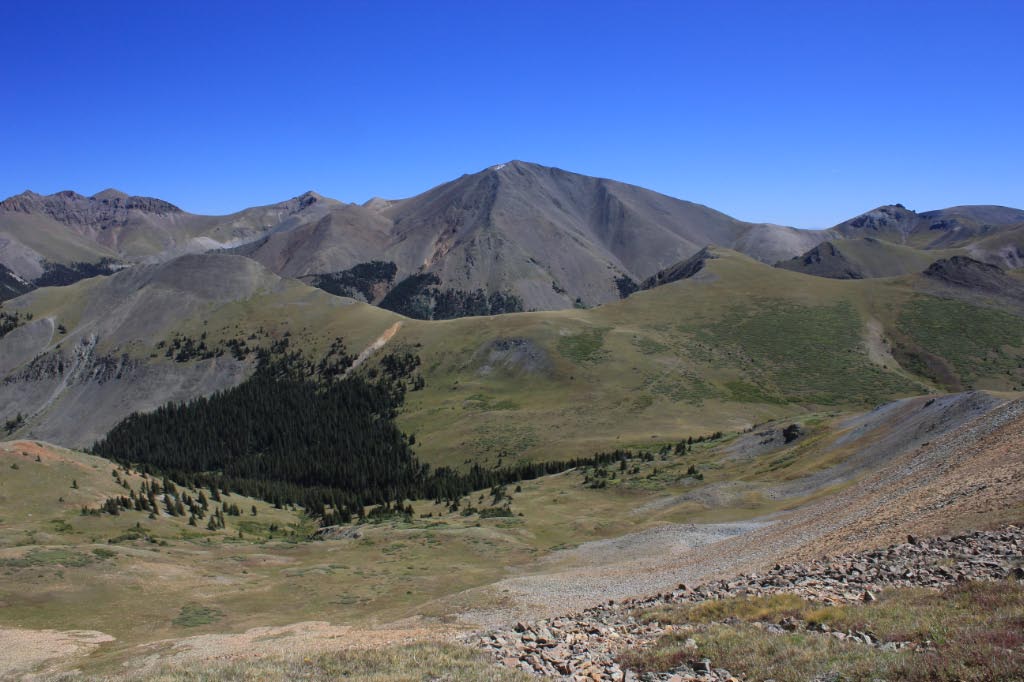
So started the longest and most epic day of this entire hike. The trail had been transformed from a path through the woods to a path up and over high passes and tundra. There were barely any trees to be seen for the rest of the day, except on two occasions. I spent almost the entire day above tree line.


The trail went over one pass, and down into a cirque, then over another into San Luis Pass. This is where Bo was heading into the town of Creede to resupply and take a zero. I was still going to walk another 15 miles, even though I barely had the energy.


There were four of five more cirques in store for me, and despite my efforts I lost count. It is really hard to describe the beauty here. To be up this high, on these mountains is really magical. There are incredible views in every direction, and the weather was a perfect blue sky the entire day. This has been one of the best days of hiking I've ever experienced.


Last but not least today was Snow Mesa. This alone would have made for an incredible day, because it is like nothing I have ever seen before in my life. After walking on or near the continental divide for many hours, the trail goes up and over one last mountain, and curves around the back side. There I was treated with a view of something I've never seen before. A massive plain, elevated to 12,000 feet and nearly perfectly flat, and miles across. The trail descended to it.


The terrain on Snow Mesa is exactly like walking on the grassy plains. It turns out it's not perfectly flat, but for the most part it is, and the walk was about 5 miles across. For that entire time I was the tallest thing for miles around. Again I was very thankful for the great weather.


I was getting tired, and ready to be done with the mesa and get down to the highway at Spring Creek Pass where I planned to camp. Just when I thought the mesa would go on forever, I saw some sheep on the horizon. Hundreds of them. They were standing right near the trail, and there was a cowboy among them on horseback, with a dog. I ended up having a very nice conversation with him, whose name is David. He's tending the flock for the entire summer, which is 1,500 head of sheep. He couldn't have been older than 22, and I got the impression that he really enjoys talking to the hikers that come through here. It really was cool to see something so unusual, and put a nice cap on an extremely memorable day.


Exhausted, I made it down to the highway after dark, and found a picnic area where I planned to camp. There were already a couple of  hikers doing the same thing. It was getting cold, but I braved it to cook up some food anyhow. I was going to sleep extremely well this night.