Showing posts with label Gunnison National Forest. Show all posts
Tuesday, August 31, 2010
The San Juan Mountains
Day 26
Miles hiked today: 14.2
Miles from Denver: 338.2
Elevation: 11,720 ft
Segments 19,20
Landmarks: Continental Divide Trail, Gunnison National Forest, Chochetopa Creek, La Garita Wilderness, Eddiesville Trailhead
VIEW MAP
I woke up this morning with a lot of dew on my tent, and a slight frost. It is getting colder, and I have a feeling its going to be that way for a while. I was pretty late in waking up, and while I was eating breakfast the sun actually came over the nearby mountain and shined directly on me. It was nearly 9 oclock.
This didn't really follow my plans for the day, which involved waking up early so that I can get 15 miles done by early afternoon, so that I could summit San Luis Peak today. San Luis Peak is 14,014 feet tall, and is one of only a handful of 14ers that are easily accessible from the trail. I have passed all the others.
Today was just one of those days where the miles slowly ticked by, while time went faster than it should. By noon I had only done 6 and a half miles, and I found myself at Eddiesville Trailhead stopping for a snack, seemingly in slow motion. 2 hours later I had only moved about 2 miles, having stopped in a beautiful meadow to soak in the sun, eat some food and dry my stuff out. San Luis was not going to happen today.
A few miles earlier I had entered La Garita Wilderness area, which is the 5th Wilderness Area the trail has come though. After these last several segments of hiking on jeep roads, I was very excited for some pristine trail untouched by motorcycles and ATVs. What's interesting is that even in the wilderness area, I was still seeing double rut tracks.
The trail at this point is following Chochetopa Creek to its source, which is what I did for the whole day. The river valley is lined on either side with an ever more impressive array of mountains the farther up the valley I travelled. According to my map I have officially arrived in the San Juan Mountains, which is what I have been looking forward to this entire trip. If this introduction is any indication, they are absolutely beautiful. But I have the feeling I haven't seen anything yet.
I had decided to stop just before the climb up to San Luis Peak, and summit in the morning. That is going to make tomorrow a very long day. As I got closer to the head of the valley, the trail became enclosed in a very ancient forest. Most of the forests I've seen in Colorado, or even in most states I've been to, have already been logged and replanted. Some of the forests on the Colorado Trail are 3rd generation, having been logged and replanted twice. This forest however, doesn't seem like its ever been touched. This is the most remote part of the entire Colorado Trail, and is also the least used by even hikers.
About a quarter mile before I reached my intended camp site I met another hiker named Bo, who was already set up for the night and was about to build a fire. It was early, maybe 5 pm. Bo explained that the camp site listed was out in the open, which would be a concern with the cold wind coming off the pass. I decided to set up my tent at his camp, and enjoy a fire for the first time on this trip, as well as some rare company.
It was very nice having a fire, and we traded stories over the campfire until after dark. Bo explained his plan to hike San Luis Peak not in the morning, but the middle of the night so that he could get up there just before sunrise. This sounded intriguing. I had done something crazy like this once before; my middle of the night hike of Blood Mountain on the AT, and was greatly rewarded with one of the most unforgettable sunrises I have ever seen. I was in. We figured that a 3:30 am start would be needed, and I turned in to my tent for what was to be a very short night, and a very long day.
Monday, August 30, 2010
Chochetopa Park
Day 25
Miles hiked today: 21.2
Miles from Denver: 324
Elevation: 9,720 ft
Segments 18, 19
Landmarks: Continental Divide Trail, Gunnison National Forest, Chochetopa Park, Chochetopa Creek
VIEW MAP
It was very hard to get out of Gunnison. I ended up spending two zeroes there. Yesterday I actually tried to leave, but I stood by the highway for over an hour and didn't get picked up. That kind of killed my motivation to hike that day, and I ended up wandering across the street into the Pioneer Museum, and ended up spending several hours there. I can highly recommend this museum, by the way.
So I found myself this morning, motivated to put some miles down, and anxious to get going, getting soaked by a rain storm on an errand I was running. This was not a good way to start the day. I ended up stalling a little longer indoors until the rain stopped, and finally I was out the door by 11. Not exactly an early start, but at least I was dry.
I had to travel over 40 miles to get back to the trail, which is first 8 miles east on Rt 50, a very busy highway, and then 33 miles south on Hwy 114, which almost nobody travels. This could be a very long wait. Within a half hour I caught my first ride, a nice guy named Brian who was literally on his way to the airport to fly to Patagonia for a 1 year NOLS training course, which is National Outdoor Leadership School. When he comes out of that course he should be able to eat thru hikers for lunch.
The second ride I caught was from a guy named Jesus, who is a carpenter. No kidding. He pronounces his name (Hey-Soos), and he was just talking about his work on the way up, so I wasn't really thinking about it at the time. It wasn't until I got on trail that it dawned on me that I had just gotten a ride from Jesus the carpenter. The nice thing was that before I got in the car, he discussed that he was going 35 miles on Hwy 114, which worked for me because I was only going 33. However, when he dropped me off at the pass, he drove off the way we had just came, so I think we passed his work site and he didn't say a word.
I finally got on trail at 12:30 pm, which is not exactly early. I am trying to make it to Silverton in 5 days, which is 106 miles away. This means that I planned to go at least 20 miles each day, and I was a little worried now. I have a 3 mile an hour pace when I really hurry, and once, on the AT I had gone 21 miles in exactly 7 hours. I never thought I would try it again on this hike, but there is no time like the present. The terrain is flat, and is supposed to be easy walking. 21 miles also happens to be how far it is to the next reliable water source. I started out at a brisk pace.
Not a half mile from the road, I came upon some trail magic. A guy named Burnfoot had stocked two coolers with soda, and there was a register there as well to sign in. The register was full of fun anecdotes, and high praise for burnfoot leaving these sodas here. Had I not been in town for nearly three and a half days the soda probably would have tasted much better to me, but I am extremely thankful all the same, and especially on this trail which is barren on trail magic, this is very welcome. Packing a root beer with me, I was also able to go the entire day without needing water.
The guidebook talks about this being one of the most scenic segments of the whole trail, but at first I just wasn't getting it. I was on roads of some sort or another the entire day. There are forest service roads, fire roads, county roads, jeep tracks and hunting roads. Not a bit of trail, and all of it accessible to horses, mountain bikes, motorcyles, ATVs and any other kind of vehicle you want to bring. This is a far cry from the footpath-only regulations I know and love, but this is offset by the fact that I didn't see a soul of any means of transport, all day.
About halfway through the afternoon I came upon the scenic part. I have learned that in Colorado, a park is what you call a vast, open space in the mountains. Chochetopa Park is such a place, and it is very impressive. It goes for as far as I could see, and is dotted with small stands of trees, with a plateau on one side, and tree covered hills on the left. At the far horizon there are some mountains, but these are so far away that they looked very tiny. This is ranch country, and a barbed wire fence cuts through the scene, until I couldn't see it any more. It is kind of like walking through a smaller version of Shirley Basin.
The trail takes about six miles to get across this, and it is a very scenic, and windy walk. I had beautiful weather, but I would not want to walk across this when it was cold, windy, raining or snowing. Eventually I got to a road, where the trail turned left on the road, up into the hills. There was still much more to Chochetopa Park.
It was getting late in the day now, and I could see that I had nearly enough time to make the 21 miles, but I
would be finishing up in the dark. Sunset came, and I was able to use the light from the sky to hike until nearly an hour past sunset. In the last couple of miles, the trail climbs 600 feet on a jeep road, then turns downhill to meet up with Chochetopa Creek. It was now nearly completely dark, but there was just enough light to shine off of the rocks, of which there were many. I was hurrying, as I wanted to get to camp and set up before any weather could set in, as there were a few dark clouds overhead. My feet moved swiftly, uncannily finding all the spots where there were no rocks, never kicking or tripping on one. I have experienced this phenomenon once before, but I have never been as sure footed when hiking as I was just now, despite barely being able to make out the contours of the trail, much less where all the rocks are. It is a really strange sensation. I flew down the hill, and finally in the last mile I was forced to stop and dig for my headlamp, as mists of rain started falling.
Luckily, the weather moved on as I found a campsite next to a gurgling creek and set up my tent. It's the worst job of setting up my tent I've done yet, and the thing sagged in crucial places. I would be very grateful if it doesn't rain on me tonight.
Friday, August 27, 2010
Gunnison
Day 22
Miles hiked today: 13.1
Miles from Denver: 302.8
Elevation: 9,680 ft
Segment 17
Landmarks: Continental Divide, Continental Divide Trail, Razor Creek, Lujan Creek, Gunnison National Forest, Rio Grande National Forest, Gunnison
VIEW MAP
Last night I contemplated making an escape off trail into Gunnison or back to Salida, on Rt. 50. I should have taken a zero in Salida, and my body is suffering for it. I have 40 miles to go to Creede, and not sure I can make it.
This morning I put all thoughts out of my head, as I was feeling better and figured the night's rest had fixed me up. I packed up and, stupidly, didn't fill my water bottles at the lake because the guidebook says there is water 3.5 miles ahead, at Razor Creek. I had about a 300 foot climb to get back to the trail, and didn't want to carry the weight. I planned on stopping for breakfast at the creek, but there wouldn't be another water source for another 9 miles after that.
Soon I encountered Thumbs Up, who had camped a little behind the turn for the lake and got going a little earlier than I did. I told him I would see him at breakfast, and pushed on.
Soon I passed a sign for the Razor Creek trail, and then a dry creek bed. Uh-oh. According to the map, this was Razor Creek, and it was dry. Thumbs Up arrived, and we put our two different maps together and determined that we were in the right spot, and there was no running creek. About a quarter mile back, uphill, there was a small little puddle where the creek crossed the trail. That was the only water for miles.
One of my all-time favorite pieces of gear has to be my Platypus water tank, which is a plastic water bag that holds 4 liters and has handles. I use it every time I filter water, putting the water first in the bag, then filtering out of the bag. This allows me to avoid putting my filter intake down in the mud, and also allows me to move the water to a comfortable sitting place so that I can pump the filter. This came in very handy just now, and before long I had two water bottles full of clear but slightly strange tasting water. It would have to do.
I told Thumbs Up about my thoughts about taking a break from the trail, and he had an overview map of Colorado and pointed out that the upcoming highway could take me to Rt. 50, and then to Gunnison. I was still feeling like I could make the next 40 miles into Creede, and told him it was just something I was thinking about.
The trail sticks pretty close to the Divide right here, which means that there is a lot of climbing and descending. Pretty soon it descended to a place called Lujan Pass, which looks like it was settled at one point, and has several spots that bear the evidence of long-ago standing buildings. The trail joins a forest road from there, and descends off the divide and down to the highway. It is also near the 300 mile mark.
As the road went down, it followed Lujan Creek which was not much more than a trickle in spots, an underground creek in others. There was thick brush or rocks in many spots preventing access, but finally I found a spot that had a nice resting spot and had access to a small flow of water. This would be the last water source for the next 20 miles of trail, potentially. I stopped and cooked my dinner as my lunch so that I wouldn't need water to cook later, and filled up my extra water bag for the long haul.
When I got going again, just a mile from the highway, I changed my mind. I was going to be suffering a lot over the next several days if I didn't take a rest, like I should have. Gunnison was about 40 miles away, but just a thumb on my part. I left Thumbs Up a note explaining my absence, and hitched into town. A very nice guy named George stopped, who commutes once a week on this road, every Friday, from San Louis to Montrose, which takes him through Gunnison. I was very fortunate he stopped, because this should be a near impossible hitch, on a road that isn't supposed to have any traffic. He said he had once picked up a thru hiker, which is why he stopped for me. He had a cooler with soda and peaches, and bid me to help myself. Hwy 114 travels for 33 miles through an unbelievable rocky red canyon, and George said there are over 500 Big Horn Sheep that live in it. Sure enough, we spotted some and we got out of the pickup to get a better look, and he had a pair of binoculars. Overall it was a nice bit of trail magic, to find such a ride in such a place, with someone who only comes that way once a week. Thanks George!
So I'm all set for a day off, and I will pick up where I left off on Sunday. Now I should be able to get all the way to Silverton without stopping in Creede or Lake City, a distance of 108 miles. I've hiked such a distance once before, in Maine's 100 Mile Wilderness, which has a great and famous sign at the start, warning hikers not to enter unless they are carrying at least 10 days of supplies. This is always a humorous photo stop for a thru hiker. I'll carry 5 days worth.
Thursday, August 26, 2010
Sargents Mesa
Day 21
Miles hiked today: 18.1
Miles from Denver: 289.7
Elevation: 11,480 ft
Segments 16, 17
Landmarks: Continental Divide, Continental Divide Trail, Tank Seven Creek, Cameron Park, Sargents Mesa, Baldy Lake, Gunnison National Forest, Rio Grande National Forest
VIEW MAP
I woke up early to a magnificent sunrise, the colors of which were already lighting up my tent in purple and pink hues. I got out of my tent, took in the sight, then went back to bed. It was still early. In what seemed like minutes later in the dream world, I awoke again with direct sunlight shining on my tent.
I had stopped just short of the water source last night, so I intended to walk about a quarter mile or however far it was and then stop and cook breakfast. Thumbs Up, who had camped somewhere behind me, came up just as I was rolling out. The two of us came upon Paul just as he was rolling out, a quarter of a mile later. It was like Thumbs Up was conducting the rolling wakeup call. They went on as I stopped for water and breakfast. Just as I was packing up, Gil came along, who is a thru-hiker of the Continental Divide Trail from Israel. He's done the Pacific Crest Trail as well, so is close to completing his second of the three big trails.
A couple of miles later, all three of them were stopped for a snack break, and I joined in, making four. This is more thru-hikers gathered in one place than I had seen this entire trail, and nearly as many as I have seen combined. Truly a rare moment on this hike. I would not see Gill again, as he is a very fast hiker, and is pushing big miles to get done.
The big water source today was Tank Seven Creek. Thumbs Up thinks Tank Seven is a reference to a water tank for a railroad's steam engines somewhere farther down. This was only seven and a half miles into the day, and already it was past noon. The miles today were not going very fast. Paul and Thumbs Up were at the water source, and soon Paul left and I stayed for a bit to grab some lunch. I hiked on just after one, leaving Thumbs Up stretched out on his mattress eating his meal. I turned right at the T junction, and started downhill. I had heard Paul mention something about how we follow Tank Seven Creek for about a half mile, but I was surprised that I was going downhill, and kept waiting for the turn away from the creek. After almost a mile I could see the trail was emptying into a valley ahead, and got a bad feeling about it. It is not unusual on this trail to not see trail markers- the Colorado Trail logo on plastic placards nailed to trees- for long stretches. But I had not seen a single marker since leaving the lunch spot, and I was losing elevation fast in a segment that was supposed to be following the Continental Divide. I got out my map, and sure enough I was following a side trail off the ridge to the north.
By the time I hiked uphill all the way to the spot where I had erred, I had wasted about an hour and a quarter, and Thumbs Up was gone. I had not looked at the sign at the T-junction. Finding the right way, I started uphill through Cameron Park, which is a meadow and used to pasture cows. These cows were not as quick to move out of my way as cows usually are, and showed a little more attitude.
Soon I found Thumbs Up stopped at a very murky mud puddle, fouled with cow poop. There was so little water in this segment that it was worth contemplating filtering the water, but ultimately both of us passed on it. He was surprised that I had gotten behind him, and I related my misadventure down the Tank Seven Creek trail.
It was almost 10 miles from Tank Seven Creek to the next water source, which was a lake called Baldy Lake, which was a half mile off trail and a 320 foot loss in elevation. Making this water source would be an 18 mile day, or I could go for Razor Creek which was another 3.5 miles. The miles were going so slow today that I decided to make for Baldy Lake.
Sargents Mesa is a very interesting place. Right now the trail is in a relatively low area, traversing between the big mountain ranges of the Sawatch Range to the north and the San Juans to the west. Sargents Mesa is a high plateau that is slightly slanted back to the east, a giant flat meadow at 11,600 feet that provides unlimited views in three directions; north, east and south. The mesa is used as pasture land, so there are a lot of cows up here enjoying the view as well.
The rest of the day went very slowly. I passed a sign that said 4.5 miles until Baldy Lake, and those 4.5 miles ended up feeling like six. I was tired and ready to stop, but the lake was the only water source. Finally I looked at the map and learned that the trail made a turn due west right before it got to the lake, which helped me stop hoping to see the sign for the side trail around every corner.
Finally the sign came, and the descent down to the lake. I was the only one there, and had this beautiful alpine lake all to myself, walled in on the far side by a steep mountain of rubble, and a well situated campsite with nice flat ground on the other. A few chipmunks officiated while I ate dinner, but other than that I didn't see or hear any wildlife.
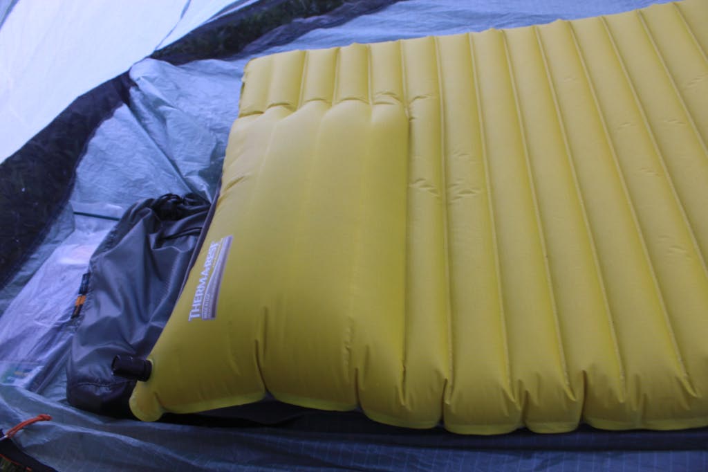
When I laid down on my sleeping mat, I heard a loud tearing sound. This is Thermarest's Neoair, the latest and greatest new thing, but it has over the last week or so transformed from a flat sleeping pad to a giant round air filled pillow. The inner baffles near the head end are seperating on the inside, and each night it gets a little worse. The tearing I heard doubled the effected area, and I'm hoping this thing holds out to the end, or until I can get REI to replace it for me.
Subscribe to:
Posts (Atom)