Sunday, August 15, 2010

Copper Mountain


Day 10


Miles hiked today: 6.2
Miles from Denver: 124.1
Elevation: 10,600 ft
Segment 8
Landmarks: Copper Mountain Ski Area, Tenmile Range

VIEW MAP


I have been looking forward to today for a while because my dad will be joining me on the hike for a few days. We have made a tradition in the last couple of years of going on hikes together, starting with him joining me on two different sections of the Appalachian Trail. The reason I stayed in Breckenridge again was because he was driving down to meet me, and this made it easy.


In an amazing bit of trail magic, my friends Melissa and Scott, who so graciously took care of me when I landed in Denver and got me to the trail with food and everything else I needed, are in town. Furthermore Melissa says they would be HAPPY to assist my Dad and I with a little logistic problem we have, which is how to get the car at the end of the segment if we park it and hike 25 miles. They are in exactly the right place on the right day to help, and more than that, they are willing. They have been up here for a wedding, so are in no big hurry to return to Denver on this Sunday afternoon.


Thus started a day which consisted mostly of driving all over the heart of Colorado, probably making an 80 mile loop between Copper Mountain, Leadville, Tennessee Pass and Vail to place my Dad's car at the far trailhead. This is so immensely helpful to us I can't even describe it. Finally we end with a nice plate of burgers at a restaurant in Vail, and it is time to get on the trail.


We are on trail by 3:00, which doesn't really matter because we only have 6 miles to walk. My Dad will be here for 3 days, and we will be doing the next 25 miles to Tennessee Pass. Right in the middle of this section is an above tree line pass that we will need to cross tomorrow, so for today we just need to camp as close as possible to the pass, which is that 6 mile mark.


It is interesting walking on a long distance trail right through a ski area. Copper Mountain has turned its lower slopes into a golf course, and the village is hopping with a big concert, trampolines and I'm sure lots of beer and food. It is even stranger being on a long distance trail, seeing all of this, and not stopping. We were still full from Vail, and were anxious to get on the trail.


After navigating through the confusing network of ski runs and mountain bike trails, we finally left Copper Mountain behind us and started up a steady climb along a stream. We camped in a big meadow next to a collapsed and long-abandoned cabin. The best guess is this was a cabin for mine workers, as mines of all sorts perforate these mountains like swiss cheese.


Tomorrow will be a much longer day, and as I packed up after dinner the temperature was falling fast. This looked to be a cold night.

Saturday, August 14, 2010

The Tenmile Range


Day 9

Miles hiked today: 13.3
Miles from Denver: 117.9
Elevation: 9,800 ft
Segment 7
Landmarks: Tenmile Range, Breckenridge, Copper Mountain

VIEW MAP

Nothing before on this trail can prepare you for crossing the Tenmile Range in Segment 7. It was fun and exciting going above tree line to go over Georgia Pass a few days ago, but this was MUCH better.


The Tenmile Range stretches from Frisco to south of Breckenridge, and if you've ever been to Breckenridge the ski resort is built right on the side of it. But there is so much to it to the south, which of course can best be appreciated by walking atop it.


I got a little bit complacent about the hike today because its "only" 13 miles, and thanks to public transportation between ski resorts I was going to hike this segment which goes over the range and finishes at Copper Mountain, then catch the bus back to Breckenridge in time for a shower and some pizza at the Fireside Inn. It's kind of like slackpacking only better, because I'm only taking public transit, and also taking my pack. Why take my pack? It's a personal thing long debated among thru-hikers, but for myself I want to hike the entire thing with a full backpack.


Anyways I was in no hurry to leave this morning, the weather was beautiful and I stopped in a restaurant for some breakfast. I waited about 30 minutes on the bus to take me to the trailhead (it's going to be rough not having this bus the rest of the trail), and was finally hiking by 9:30 AM. There were quite a few things I didn't fully appreciate about this Segment at this time, but the numbers were right there in the datebook: 3,600 feet elevation gain to 12,440 feet, and 4 miles above tree line.


I may be a thruhiker, but I've only been on the trail for a week, and I'm not exactly in shape yet. In fact it may take more than 485 miles to make that happen. This climb up was very tough, and took much longer than I anticipated. When I got to tree line, I met a nice couple from the area named Roger and Joyce, who were going to Copper Mountain like I was. We chatted for a bit about my hike, and when it was time to go up, it turns out their pace is about the same as mine. Roger is in extremely good shape and barely paused for breath on the climbs, and Joyce is slower than I am but just barely. So I ended up hanging out with them for the entire afternoon, almost like having one-day hiking partners.


The hike was epic. Being on top of the Tenmile Range is like being in mountain heaven. There are mountains as far as you can see in all directions; jagged ones, flat ones, hooked ones and rounded ones. There are mountains piled on top of mountains, and some by themselves. The weather stayed beautiful the whole time, and I was giddy with excitement over all the views and photographs. As Roger said, "This is special." I couldn't agree more.


Roger and Joyce were kind enough to give me a ride into Frisco at the end of the day, which was one-half my bus transport. It was kind of relaxing to ride the bus, watching people get on and off coming home from work. When I finally pulled up in Breckenridge, I made a beeline for the Fireside Inn, who were pleased to see me, and very soon I had a shower, pizza and lots of good conversation with my fellow hostel mates. There was even an AT thru-hiker alumni staying there this night.

Friday, August 13, 2010

Breckenridge


Day 8

Miles hiked today: 3.4
Miles from Denver: 104.6
Elevation: 9,200 ft
Segment 6
Landmarks: Breckenridge, Breckenridge Ski Area, Fireside Inn

VIEW MAP

Town day! My friends Keychain and Zen had a dance for this, but I can't remember it. All I know is I was going to have a shower very soon. And lots and lots of food. And laundry. And maybe some food.


I had called the hostel in Breckenridge yesterday to make sure they had space, and they said to come after 10:00 AM because of people checking out. Since I was only 3.4 miles from the road, I decided to sleep in and take my time. For once I let my tent stay up long past sunrise, letting the sun dry it out a bit from the dew. I ate a bland breakfast of oatmeal, knowing I would soon be eating much better. Finally I got rolling around 8:30, my latest start yet.


A friend had told me that the forest around Breckenridge is being decimated by some kind of beetle, but I was really shocked to see it. In any of the pictures, if you see reddish pine trees those are dead pine trees. From afar it has the effect of looking upon a deciduous forest that is going through fall colors. Up close, roughly half the trees to my eye are sick and dying, or already dead. Their trunks open up with gashes of bleeding sap, their needles turn brown or maroon and for the ones that have been dead for some time, they start to fall. They have started a cutting program here of the dead trees, and in some of the sections half the trees are lying on the forest floor, chopped down and aged into perfect, dry firewood. The entire forest floor is covered with these grey logs, a perfect tinderbox. It would not take much for this entire valley to go up, and Breckenridge with it.


The walk down into Breckenridge was interesting, because the trail comes in right above a big housing development, businesses, giant vacation mansions and tennis courts. It is kind of strange to look upon all of the activity of everyday life, that has been continuing like normal since I left civilization 8 days ago. All these people have access to a shower every day, running water, grocery stores. There is no change for them while I am in the woods. The world continues on.


The really nice thing about Breckenridge is it has a free bus service that services the trailhead. This, along with Copper Mountain in the next segment, are the only places on the whole trail you can catch a bus. So, no hitchhiking this time. Easy peasy. I was lucky that I got down to the bus stop at 9:50, to learn that the next bus is 9:55, the one after that 10:55.


Breckenridge is a hyped up ski town, with lots of boutique shops for folks with lots of money, lots of "mountain" motif going on with the architecture, signs, logos, business names, etc. Everything plays to the visitor, the tourist and the pocketbook. Even though Breckenridge has a long history going back to at least the 1860's (I did not look up how far it really goes back but I did see a photograph dated 1860's.) it still just doesn't quite feel real, like a town that has been built in the last 30 years. At least, that is my impression as I walk around the place until I came to the hostel/bed and breakfast I was staying at, the Fireside Inn.


The Fireside Inn is quite a unique experience, and ranks near the top of all the hostels I have been to. It is run by Andy and Niki, a British couple who seem to have just brought a little piece of England with them. There are British and American flags flying out front, and the sitting room is decorated with all kinds of British Military memorabilia from Andy's career in the military. The have two poodles, one named Gaspode who is the mascot on the t-shirts, one of which I was given to wear around town along with some purple flower swim trunks as my clothes were washed.


The shower, the laundry, and the food. Those are really the first 3 things any hiker worries about when first getting in to town, and I was no different. I asked for a recommendation on a burger joint and was directed to a place called Imperial Burger, where I managed to eat lunch. The waiter who brought out my giant burger, giant plate of cheese fries and two beers kind of shook his head and smirked, but I had him singing a different tune 10 minutes later when the burger was gone and I was halfway through the fries.


The hostel was filled with all kinds of interesting people, each of whom were doing their own unique thing. There was a guy named Bruce who was out here climbing fourteeners, (Colorado has 56 peaks over 14,000 ft, so people try to climb them all over a course of time) Charles who will be running the Leadville 100 next weekend, which is a 100 mile race in 30 hours over mountain terrain, I think some of it on the CT, two guys from Michigan who drove down to climb Mt. Elbert, Bill who was biking across America, and so on. It was a great experience staying here, and brought me back to the many hostels I stayed at on the AT. This is a part of trail life, and one that the CT will only have in very small doses, it seems.

Thursday, August 12, 2010

Georgia Pass


Day 7

Miles hiked today:  23
Miles from Denver: 101.2
Elevation: 9,400 ft
Segment 6
Landmarks:  Georgia Pass, Continental Divide, Continental Divide Trail, Mt. Guyot, Keystone Ski Area

VIEW MAP


Wow.  23 miles today, two big climbs and two storms I'll never forget.  Where should I start?


I think that I could have actually made it over the pass yesterday, but it would have been a very long day.  All indications were there for a clear evening, and now I know that there are campsites much closer on both sides.  I awoke this morning to the sound of heavy winds, and only half the sky was clear.  It was about 6:30 AM.  Within a few minutes, I was driven back into my tent because of rain.  This was going to be an interesting day on the pass.  I decided that when the rain quit I would skip breakfast and boogie as fast as I could.  I had 6 miles and about 1,800 feet to climb, the last three quarter miles of that above tree line, and probably a quarter mile off the other side before re-entering tree line.  That mile at the the top is where you don't want to be when a storm hits.


I made pretty good time getting up to the Divide, and the views were breathtaking.  It is one thing to look at these mountains from far away and be in awe; it is quite another to approach them, walk past them, and see how they look different from every angle.  There were a whole row of peaks, all connected by "knife edge" walls of rock.  There were tiny glaciers still in place on some of them.  One was all red, probably due to iron deposits.  Mt. Guyot stands above them all, the guardian of Georgia Pass.  The pass itself is surprisingly tame in comparison.  Approaching it, you are above tree line only briefly, and there is still grass and hardy plants growing at the pass.  The pass is  at 11,860 feet.  If you look at a distance, there is this surprisingly low spot off the right shoulder of Mt. Guyot.  That is why settlers first noticed it and used it, and it became the gateway for thousands descending on Leadville and Breckenridge during the silver rush.  In fact the old road that their wagons would have used still exists, and I crossed it today.


My timing was perfect.  I had breathtaking views of Mt. Guyot and the other peaks in the divide all the way up, and as I crested the rise I was treated with my first view of the Tenmile Range, which I will be on in a couple of days, and what seemed to be the rest of Colorado.  That is, a view of the Tenmile Range with those distinctive tall, dark clouds preceded by rolling pin shaped clouds.  I was about to be in a bit of trouble.  In as much time as it took me to eat a snickers bar and snap some photos, those lead clouds hurdled the Breckenridge Valley below, and I could see the grey wisps of rain enveloping the flanking peaks of Mt. Guyot.  It was a strange sight because the sun was still out behind me, and Guyot was illuminated beautifully by the sun, framed by an ugly grey cloud that was about to swallow it whole.  That was my last picture, as I struggled to put my camera into its ziplock baggie on the run.  There was no thunder or lighting, just all wind and rain, like a freight train.  I had noticed that the trees were not very far, but what I failed to notice is that the trail went first across the rim of the pass to the far end before entering them.  It was probably 120 yards, and I didn't make it before getting slammed with ice cold rain drops traveling sidewards at what seemed to be 40mph.  Thank God I put that camera away when I did, or it would have been toast.  In a matter of moments I was soaked head to toe, and I could tell it was cold enough to cause me some problems if it lasted much longer than say, 20 minutes.  I looked over my shoulder and Mt. Guyot was gone, swallowed by the grey mass.  I made it to tree line ok, and after about 15 minutes the storm died down, and the sun came out.  I found a nice campsite with direct sun, and in no time myself and all my gear were basking in 80 degree sun.


Walking down the other side of the pass, I was greeted with views of mountains I hadn't yet seen far off in the distance, having traded those that are behind on the other side of the pass.  The guidebook here explains that the trail used to just run along a dusty dirt road with lots of traffic, and they were finally able to re-locate it up the side of a mountain.  What this really means is that they put in another big climb up the west ridge of Keystone Ski Area, about half as big a climb as the pass itself.  I was feeling good however, and it was early in the afternoon so I took the plunge.  On top of this ridge I was caught in another storm, this time a hail storm.


Yet again the storm dissipated and the sun came out, and before long I was coming up on my intended camp site.  The problem was, the guidebook says there is water here and I didn't see any water.  So I kept walking, another 3 miles, pushing my day into the long and very tiring category.  I climbed yet another hill, and back down the other side before coming to Horseshoe Gulch.  There was water but no campsite! Very tired now, I filled my water carrier with 4 liters and trudged up yet another hill, until I found a campsite about a half mile up.


It turned into a very nice evening, and once I got settled I was very happy.  The longest day yet, and my feet felt fine.  I was now just 4 miles from the road that would take me into Breckenridge and civilization, and I was very much looking forward to a shower and a very large plate of food.

Wednesday, August 11, 2010

Kenosha Pass


Day 6

Miles hiked today:  10.1
Miles from Denver: 78.2
Elevation: 10,000 ft
Segments 5,6
Landmarks:  Kenosha Pass, Jefferson, Mt. Guyot, Jefferson Creek

VIEW MAP


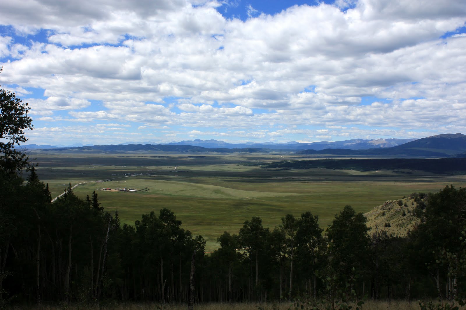
I rose early after the first rainless day and night so far.  There was not even a dew covering my tent, and it was nice to put it away dry.  I ate a light breakfast because I was headed in to town, and packed up quickly.  My camp site had a view of the Continental Divide, and the peaks were already lit up when I set out at 6:30 AM.


It was chilly but just the right temperature for a brisk walk.  I wanted to get down to the road early because who knew how long it would take to catch a ride.  It is one of those experiences that every thru-hiker knows well: the suddenly hyper-attuned ear for the sound of the highway on a town day.  In this case I could actually see the tiny hamlet of Jefferson from far away as early as yesterday; it looked to have maybe a dozen buildings with ranches spread out in all directions, and a huge snow fence striking a tan line to the northwest of town.  I could see tiny cars zipping in and out of town on US 285, which would soon take me there as well.  But this was only what I could see from the vistas from far away, as I got closer I was enveloped by woods but my ear picked up the sound easily of the busy highway of trucks and cars, drawing steadily closer.


Kenosha Pass has seen generations of travelers use it to access the interior mountain ranges of the Colorado Rockies.  There are still some railroad tracks preserved from the Denver, South Park and Pacific line that ran here from Denver until the 1920's.  The switchyard was actually right at the crest of the pass, utilizing the flat ground there.  You could catch a train from Denver to Breckenridge in just 6 hours, and there were 3 competing rail companies that ran to different parts of the Rockies.  All 3 went under due to a combination of the silver market dissipating, the trucking industry and the great depression.  It is strange that building something like that seems so out of reach to us today.


Hitch hiking is simply a part of life on a long distance trail.  I don't really know anybody who truly enjoys it, and it is always an anxiety filled experience for both hiker and driver.  For me it is the prospect of standing by the road for hours as car after car whiz by that gives me the most anxiety.  Some of them actually wave as they drive past!  It is harder to do if you are male, and have a scraggy beard.  Being alone doesn't help either.  If there are two people I think you are better off, but 3 might be too many for most seating situations.  What helps most of all is if one of the party is female.  Here, let's play multiple choice: 1. scraggy beard guy alone, 2. two scraggy beard guys, 3. scraggy beard guy with non-bearded female, or 4. two non-bearded females.  Now which of the above combinations would you put in your Subaru Outback?  The amazing thing to me was that this is Colorado, and therefore half of all vehicles are pickup trucks, yet they still weren't stopping.  Pickup beds are the PERFECT place to throw dirty hikers.  You don't even have to talk to them or worry if they're going to mug you for ramen.  Just pull over at the destination and give one of those waves out the open window.  I saw one pickup that had three tough looking cowboys inside.  Comon, what's to be afraid of boys?  Think I'm going to steal your fence post digger?  I will say that us hikers have an advantage over our homeless or otherwise drifter type hitch-hiking brethren: the trail.  That is, there is a completely legitimate reason that I am standing by the side of the road with my thumb out, and that is that I'm hiking to freakin Durango and my car is otherwise inaccessible at the moment.  This means that in theory, there are people who understand that the Colorado Trail exists, crosses where I am standing, and that hikers often need rides might put all of those clues together when they see I am dressed the part, plus make a split second decision on whether I look too creepy or too dirty, all within enough time to slam on the brakes before the 50 yard pull over area runs out.  It's a great theory, but it works a whole lot better in Vermont.  I even stood by the "Colorado Trail Parking" sign and gave a whole lot of room for cars to pull over, and still saw probably 100 cars go by in a half hour.  I got plenty of shocked looks, especially from older people.  Some of the faces were priceless.  Some people pointed.  Several were texting or on their phones and didn't even see me.  One woman who was standing in the parking lot behind me took a picture.  I'm sure I strike a cutting figure with my pack on and thumb out against that Colorado blue sky.  And one guy waved.  Please, don't be THAT guy.


Finally a semi pulled over, and I was thrilled to ride in my first semi truck.  As I sprinted the 50 yards or so to the cab, I found it locked.  I walked around, only to find the driver checking his brakes for the descent down the pass.  He can't take riders.  Ok. Ultimately a local guy I was chatting with earlier as he was gearing up his mountain bike came back from his ride.  He was about my age and seemed like a pretty normal guy.  I asked if he wouldn't mind giving me a ride, and he was nice enough to do so, even though it was out of his way.  Bo was his name I think, and he had even done some long distance hiking himself.  So, score one for trail magic today!


The town of Jefferson is quite nice.  It is probably even smaller than Stratton, Maine, and has all trail towns I've ever been to beat; you only need to go to one place. Jefferson Market it's called, and inside is made to order food, groceries, homemade cinnamon rolls, and tucked in one corner behind a window is the post office.  The people there were super friendly, and there were 5 locals sitting down chatting over coffee.  This was my kind of place.  There was just one problem however, that is on Tuesdays and Wednesdays the kitchen is closed because they are making fudge.  Just my luck.  All was well however when one of the ladies (really wish I could remember names better) brought me to the back deep freezer, which was full of all kinds of frozen burritos, frozen chimichangas, frozen hot pockets, frozen egg sandwiches, etc.  I grabbed several of those, and one of those cinnamon rolls and all was right with my world.  My mail drop had arrived, which was the whole point anyways and I was now set for the next several days until Breckenridge.  I caught a ride back to the trail by asking a local guy (they said he runs the bake shop across the street).  He didn't look too thrilled, but it's just a 10 minute round trip and I think that people, when asked, find kindness in their hearts.  Or pity.


Back to the trail.  I was very excited to run into two actual thru-hikers, going towards Denver.  They weren't just any thru-hikers either, they were Appalachian Trail thru-hiker alumni.  They were a couple, it sounded like they met on the AT several years ago.  I know for sure the guy's name was Six Two, and the girl's was E-something.  Dang.  Names!  (guys if you want to sign into my guestbook and set me straight on this I'll edit this post)  Anyways it was a lot of fun to stop and chat with them, and we passed a lot of time talking about gear we used in the 90's, how to hike with an umbrella, and the fact that Six Two carries all of their food in a battleship of a pack.  It was fun to reminisce, and made me wish there were at least a few hikers going my way that weren't hiking twice my speed, or half my speed.  Ah well.  A few miles later I ran into another thru-hiker who had come from Durango in about 3 weeks time.  She confirmed that there were waves of 15-20 thru-hikers per day several weeks ago.


I pulled up way short today because I am about to cross the Continental Divide, which is 6 miles from the last place I could camp.  The next camping spot on the other side is another 7 miles beyond that.  So, a 10 mile day or a 23 mile day.  I'll be ready for those 23 and 25 mile days soon, just not this day.

Tuesday, August 10, 2010

South Park


Day 5

Miles hiked today:  18.7
Miles from Denver: 68.1
Elevation: 10,200 ft
Segments 4,5
Landmarks:  Lost Creek Wilderness Area, Rock Creek, South Park

VIEW MAP


This trail is an unbelievable find.  I had nearly 19 miles of the most beautiful terrain to myself today.  The trail is beautifully maintained, and seemingly seldom used.  There was a note in the guidebook about a "boggy section" that has been giving trail crews headaches for years. Visions of New York, New Jersey, Massachusetts, and worst of all, Maine bog bridges crossed through my mind.  The kind of bog that swallows the bog bridges down whole.  Or maybe just be like Vermont or Adirondack State Park and let the bogs swallow the hikers.


But, not here. By "boggy" they actually meant a little bit of mud, where if you pick your footing carefully you're guaranteed dry passage.  I think the standards of bogs are slightly different out here.


No kidding, I did not see a single soul on the trail today.  There was one guy who waved at me as I left the campsite, but that was before I stepped back on the trail.  I walked up a 5 mile long meadow filled with at least 200 cows, all of whom gave me a rude look.  I was the uninvited guest.  I had a blue sky throughout the morning, and am really glad I brought long pants, long shirt and a hat.  In fact the only part of me exposed to the sun are the tops of my hands, which are burned pretty good.  The long meadow is about a quarter mile wide, 5 miles long and lined on either side by mountains.  When I got to the far end I was at the top of a pass, which I soon saw when I came to a viewpoint was really a very high saddle, and I was about to drop down the other side.  From the viewpoint I could see for the first time the Continental Divide.  It is an impressive site, being on top of a really tall mountain and looking across at mountains 15 miles away that look way taller than what you're standing on.  Some of them still have chutes of snow or glaciers visible.


The long meadow was actually outside the Lost Creek Wilderness, but only just along side it.  Now that I reached the saddle and started to descend I was back in the wilderness area, and I was much more impressed this time.  It was simply a very beautiful hike.  Gone was the logging road and seeded forest I experienced yesterday, replaced by a beautiful trail that hugged the contours of the mountain to the right of the trail, and endless aspen.  I probably saw more aspen today than I've seen in my whole life.  The sun stayed out, but there were plenty of fat lazy clouds to make the pictures more interesting.  For the first time there were no afternoon thunderstorms or even thunder.  And again it struck me that I have this place all to myself.  Why is this place not choked with people?  This is gorgeous!


I had just made a decision today to slow up a little bit and camp about halfway through this segment, instead of pushing to the end for a 23 mile day.  I get my resupply at the end of this segment, and I just ate my last dinner tonight, and my last breakfast will get me to the road tomorrow.  So I intended to get water at Rock Creek, just outside the Wilderness area and and find a place to camp and call it a day.  Wouldn't you know there was a very nice little campsite right there just past the creek.  But as I took my pack off I was hit with inspiration: it wasn't going to rain.  Of course this was just a guess, but the weather today behaved very differently than the other 4 days before.  So far I have been hit consistently with a thunderstorm between 2 and 6 pm.  So, I cooked my dinner there so I wouldn't have to haul water and decided to hike on.


Gone were all of my thoughts of ailments like blisters, etc. where to camp, where to find water or even how far I should go.  As the sun decanted to the west and the most impressive lineup of clouds marched by to the north, I entered into a low area (if 10,000 feet can be considered low) full of rolling hills that offered panoramas of the Divide as well as a vast area to the south known as South Park.  The sun was low and the lighting was awesome, and the trail just kept presenting view after view.  I ended up finding a flat area in a stand of aspen with a view of Georgia Pass, the place where I'll cross the Divide tomorrow or the next day.  And I am very glad I didn't stay in that little campsite tucked by a river.