Day 21
Miles hiked today: 18.1
Miles from Denver: 289.7
Elevation: 11,480 ft
Segments 16, 17
Landmarks: Continental Divide, Continental Divide Trail, Tank Seven Creek, Cameron Park, Sargents Mesa, Baldy Lake, Gunnison National Forest, Rio Grande National Forest
VIEW MAP
I woke up early to a magnificent sunrise, the colors of which were already lighting up my tent in purple and pink hues. I got out of my tent, took in the sight, then went back to bed. It was still early. In what seemed like minutes later in the dream world, I awoke again with direct sunlight shining on my tent.

I had stopped just short of the water source last night, so I intended to walk about a quarter mile or however far it was and then stop and cook breakfast. Thumbs Up, who had camped somewhere behind me, came up just as I was rolling out. The two of us came upon Paul just as he was rolling out, a quarter of a mile later. It was like Thumbs Up was conducting the rolling wakeup call. They went on as I stopped for water and breakfast. Just as I was packing up, Gil came along, who is a thru-hiker of the Continental Divide Trail from Israel. He's done the Pacific Crest Trail as well, so is close to completing his second of the three big trails.

A couple of miles later, all three of them were stopped for a snack break, and I joined in, making four. This is more thru-hikers gathered in one place than I had seen this entire trail, and nearly as many as I have seen combined. Truly a rare moment on this hike. I would not see Gill again, as he is a very fast hiker, and is pushing big miles to get done.
The big water source today was Tank Seven Creek. Thumbs Up thinks Tank Seven is a reference to a water tank for a railroad's steam engines somewhere farther down. This was only seven and a half miles into the day, and already it was past noon. The miles today were not going very fast. Paul and Thumbs Up were at the water source, and soon Paul left and I stayed for a bit to grab some lunch. I hiked on just after one, leaving Thumbs Up stretched out on his mattress eating his meal. I turned right at the T junction, and started downhill. I had heard Paul mention something about how we follow Tank Seven Creek for about a half mile, but I was surprised that I was going downhill, and kept waiting for the turn away from the creek. After almost a mile I could see the trail was emptying into a valley ahead, and got a bad feeling about it. It is not unusual on this trail to not see trail markers- the Colorado Trail logo on plastic placards nailed to trees- for long stretches. But I had not seen a single marker since leaving the lunch spot, and I was losing elevation fast in a segment that was supposed to be following the Continental Divide. I got out my map, and sure enough I was following a side trail off the ridge to the north.

By the time I hiked uphill all the way to the spot where I had erred, I had wasted about an hour and a quarter, and Thumbs Up was gone. I had not looked at the sign at the T-junction. Finding the right way, I started uphill through Cameron Park, which is a meadow and used to pasture cows. These cows were not as quick to move out of my way as cows usually are, and showed a little more attitude.
Soon I found Thumbs Up stopped at a very murky mud puddle, fouled with cow poop. There was so little water in this segment that it was worth contemplating filtering the water, but ultimately both of us passed on it. He was surprised that I had gotten behind him, and I related my misadventure down the Tank Seven Creek trail.

It was almost 10 miles from Tank Seven Creek to the next water source, which was a lake called Baldy Lake, which was a half mile off trail and a 320 foot loss in elevation. Making this water source would be an 18 mile day, or I could go for Razor Creek which was another 3.5 miles. The miles were going so slow today that I decided to make for Baldy Lake.
Sargents Mesa is a very interesting place. Right now the trail is in a relatively low area, traversing between the big mountain ranges of the Sawatch Range to the north and the San Juans to the west. Sargents Mesa is a high plateau that is slightly slanted back to the east, a giant flat meadow at 11,600 feet that provides unlimited views in three directions; north, east and south. The mesa is used as pasture land, so there are a lot of cows up here enjoying the view as well.

The rest of the day went very slowly. I passed a sign that said 4.5 miles until Baldy Lake, and those 4.5 miles ended up feeling like six. I was tired and ready to stop, but the lake was the only water source. Finally I looked at the map and learned that the trail made a turn due west right before it got to the lake, which helped me stop hoping to see the sign for the side trail around every corner.

Finally the sign came, and the descent down to the lake. I was the only one there, and had this beautiful alpine lake all to myself, walled in on the far side by a steep mountain of rubble, and a well situated campsite with nice flat ground on the other. A few chipmunks officiated while I ate dinner, but other than that I didn't see or hear any wildlife.
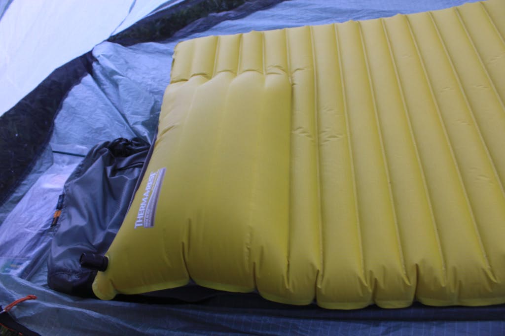
When I laid down on my sleeping mat, I heard a loud tearing sound. This is Thermarest's Neoair, the latest and greatest new thing, but it has over the last week or so transformed from a flat sleeping pad to a giant round air filled pillow. The inner baffles near the head end are seperating on the inside, and each night it gets a little worse. The tearing I heard doubled the effected area, and I'm hoping this thing holds out to the end, or until I can get REI to replace it for me.